TowWorks, a U.S.-based leader in marine management software, has upped the ante with its industry first Voyage Planning module. “Voyage Planner, like all of our modules, is capable of operating as stand-alone software or as part of TowWorks integrated suite of software solutions for the marine industry” said Richard Tiller, TowWorks founding partner.
“We utilized our experience with TowWorks’ fleeting, line haul and unit tow modules combined with our compliance software; mixed in our existing customers’ specifications and the existing regulatory and industry requirements to develop an easy to use Voyage Planning tool,” said Austin Bugg, sales manager with TowWorks. “Our graphic user interface with drag and drop icons is a game-changer in a software industry known for its often complicated and confusing data entry requirements. We understand that today’s wheelmen are being burdened by more and more external regulatory and internal company requirements to document, plan and manage every aspect of the vessel, tow and crew operational safely; while also piloting the vessel. Our goal is to help the actual users of the software fulfill those requirements by making our software as intuitive and user-friendly as possible.”
“I’m a captain, not a secretary,” said Tiller, referring to the most common complaint received from mariners. “Our user interface allows a captain to pick up, drop or shift barges from their tow with just a few mouse clicks on the drop-down menus, while also completing the necessary log entries—no typing required.”
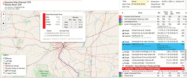
“With the click of a button in Voyage Planner, a wheelman can create a voyage plan that does all of the route planning for him by pulling in the start and destination locations from his current orders,” said Bugg. “The software then plans and maps the route, adding local notices to mariners, weather, river stages, locks and bridge information to include dimensions and air-drafts; all combined into an easy-to-read log that is continuously updated throughout the voyage.
The only additional requirements, according to Bugg, would be the completion of any pre-sail checks, navigation assessments or watch change checklists that are required by the individual company’s Towing Safety Management System, which are then completed on user-designed and built checklists and forms.
“Voyage Planner is constantly updating the weather and river stages throughout the trip,” added Tiller. “We pull in data from local weather stations and river gauges as the vessel is passing through the area, so the vessel is receiving real-time updates throughout the voyage. We pull the data straight from the National Oceanic and Atmospheric Administration (NOAA) and Corps of Engineer sources, so you are getting what they are getting. We wanted to cut the lag time between the reporting sources and the vessel.”
Tiller said that typically, someone in the office is pulling the data, compiling it into the company format and then sending it out to the boats. “We have cut out the middleman and present the information directly to the mariner from the source without any third-party delays,” he said. “We color-code our river segments to reflect the color coding on NOAA river stage charts, so you have a quick visual reference for the river conditions you are transiting through.”
The TowWorks Voyage Planner consists of two different graphic representations of the same data. There is a route map showing user-selected information; such as local notices to mariners, bridges, locks and dams, etc., with pop-up notices and the voyage log that shows the same information in a log-type format that is organized by river.
The voyage log lists the local notices in a highlighted box at the top of the screen with drop-down information, while the various river gauges, weather stations, bridges and locks are organized by river mile in ascending or descending order depending on the direction being traveled—all neatly organized by river.
“We also have an internal notices section that the companies can use to post internal notices and information about certain areas or segments of the route,” said Bugg. “If a company has a policy requiring that two wheelmen be in the wheelhouse when making a bridge at certain river stages, this is where you would put that information. As the vessel nears the designated location, a notice will appear reminding the wheelmen about the requirement or it can be a notice that a company or other vessel has reported shoaling or other navigation hazards that may not have appeared as a local notice yet.”
Bugg said that so far, everyone who has seen the demo has had nothing but praise for the concept and its execution. “We took something that is needed by the industry and turned it into a reality,” he added.


