Two storm fronts moved across the Midwest over a three-day period, dumping more rain on waterlogged soils and already-flooded rivers. The second front, moving through on May 23 and 24, brought tornadoes to central Missouri and Oklahoma, including one in Jefferson City, Mo., that killed three people.
Barges Sink At Oklahoma Dam
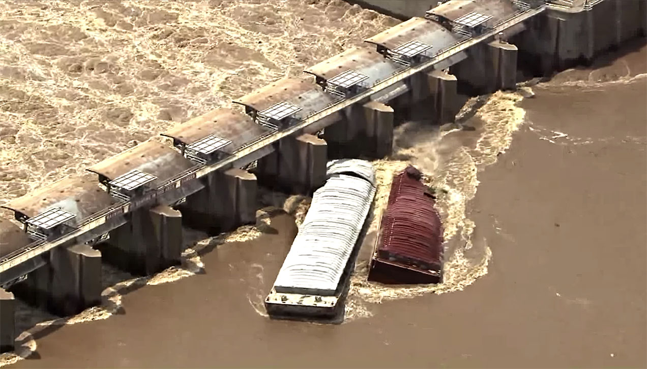
On the Arkansas River, two barges broke away from a mooring and raced downriver. The Sequoyah County (Okla.) Sheriff’s Office said crews were attempting to secure the barges, initially found stuck on a rock jetty several miles upstream from Webbers Falls Lock and Dam 16 Thursday morning, when they broke loose a second time.
Dramatic video footage of the barges—still tied together—striking Lock and Dam 16 at the small town of Webbers Falls, Okla., was captured by news helicopters in the early afternoon of May 23. Webbers Falls is about 70 miles southeast of Tulsa, Okla., and upriver of Fort Smith, Ark.
Both barges sank within about a minute of striking the dam.
Local news sources reported that the town’s 600 residents were evacuated after a Facebook posting on its official page said the runaway barges posed a dire threat to the river town’s 600 residents: “Evacuate Webbers Falls immediately. The barges are loose and has the potential to hit the lock and dam 16. If the dam breaks, it will be catastrophic!! Leave now!!”
The Arkansas River was temporarily closed to traffic at press time. The Corps of Engineers told local media they would have an assessment of the dam’s stability by 6 p.m.
Upper Miss, Illinois Rivers
The Coast Guard announced May 23 that it again closed portions of the Mississippi and Illinois rivers to all vessel traffic due to extremely high water levels and fast-moving currents.
The St. Louis Harbor was closed from Mile 179 to Mile 184 on the Mississippi River. A no-wake order was issued on the Illinois River from Mile 10 to Mile 80.2.
Outside the river closure zone, the Coast Guard said it “strongly encourages” that southbound transits on the Mississippi River between Mile 179 and Mile 168, and through the JB Bridge, occur only during daylight hours. Vessel operators may request permission to move within the closure zone. Movements within the closure zone will be limited to monitoring waterway conditions and enhancing port safety.
For vessels to move within the closure zone, operators must get permission from the captain of the port representative at the Coast Guard Sector Upper Mississippi River command center, via VHF Ch. 16 or 314-269-2332, at least 30 minutes prior to movement. The captain of the port will review each request to move within the closure zone on a case-by-case basis.
The Coast Guard captain of the port determines when to issue a river closure by following a waterways action plan, which provides the marine industry, Coast Guard, U.S. Army Corps of Engineers, state and local governments with a coordinated plan for facilitating the safe and orderly movement of traffic during extreme conditions on the inland rivers.
Caption for top photo: Screen shot from KFOR-TV video of barges hitting Webbers Falls Dam on May 23.


