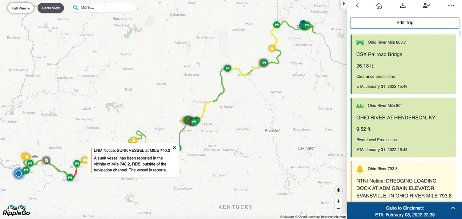
RippleGo software is designed to be as useful to the maritime industry in planning a trip on water as GPS software is on land.
Currently in beta testing, the web-based application uses machine learning and predictive analytics to provide constant updates in voyage information between a vessel’s departure and arrival points.
“This is a first-of-its-kind tool that is doing predictive analytics on the inland waterways based on AI (artificial intelligence),” said Art Salindong, managing director.
RippleGo is a voyage planning tool and alert system that uses predictive analytics to monitor and analyze dozens of data sources to provide accurate, real-time notifications on current conditions and forecasted changes along a voyage. That includes changes in river level conditions, navigation hazards, lock status changes, bridge air gap clearance and weather forecasts. The software provides updated river level predictions and travel time statistics, automatically updating a vessel’s estimated time of arrival (ETA) as conditions change.
“It’s meant to be a tool where the mariner doesn’t have to look up a lot of information,” Salindong said. “It is displayed as a web application and updates automatically as their vessel transits.”
RippleGo creates a voyage plan report automatically. It also generates a deck log with the ability to make manual entries. Alerts notify mariners of changes in bridge clearances, lock status or river level conditions and marine safety information all displayed by mile markers on the planned route, allowing mariners to make timely adjustments to their plans. Alerts are monitored and updated continuously. All the information is stored in a secured, cloud-based environment that only the client can access.
Currently available for use on the inland waterways, developers plan to expand RippleGo for use on intracoastal waterways and in harbors as well.
RippleGo began as a research and development project with the U.S. Army Corps of Engineers about five years ago, said Joe Celano, RippleGo’s director of business development.
It is designed so that vessel operators who used to spend hours putting together a voyage plan can simply enter departure and arrival points and get all the information they need at the click of a button, knowing that the information will automatically be updated as they go along the way.
The software can be used as a tool to instantly determine whether a tow can clear a bridge or if the vessel should slow down to save fuel while a delay ahead is allowed to clear.
“Progress with AI-based travel analytics has been made on the ground transportation side,” Celano said. “Now we’re doing it on the water side.”
Additionally, RippleGo can be used to provide a reliable time of arrival for ports and terminals, helping to adjust scheduling and equipment needs, Celano said.
Customers using RippleGo know a product’s ETA and can plan around that, he said.
David Sathiaraj, RippleGo’s director of data science, said the program also takes the guesswork out of voyage planning. So far, he said, models have proven to be 92 percent accurate over seven days. Because of the accuracy of the river forecasts and ETAs, voyage planning with RippleGo has become more insightful and simplified than ever before, he said.
In the end, he said, the developers wanted to make a tool that was known for its ability to simplify many of the tasks captains and crew have to take on, provide efficiencies in vessel operations and improve barge loading calculations, all while improving voyage safety and ensuring compliancy with Subchapter M.
“They’re checking weather from one source,” Sathiaraj said. “They’re checking notices to mariners on a radio channel. They’re checking river levels from NOAA forecasts, and then they’re looking at marine safety bulletins on another source.” With RippleGo, he said, all of that information is available on one screen, via either a desktop or laptop computer.
With RippleGo, mariners can have confidence in the predictive analytics, while the interface is designed to be simple to aid in ease of operations.
“We’re really trying to help the mariner simplify their life,” Celano said, adding, “Mariners know how to navigate. That’s what they do. We’re here to provide all that other information they’ve got to look up that helps them do their job safely.”
RippleGo uses a vessel’s AIS system. Because it is web-based, it doesn’t require a particular type of computer operating system. The software is subscription-based with a monthly fee. RippleGo is glad to provide a demonstration of the software for interested companies and is looking for companies interested in beta-testing the software.
For more information, visit www.ripplego.com.
Caption for photo: Screenshot from RippleGo shows how the software uses artificial intelligence and predictive analytics to help plan voyages, including automatic bridge clearance calculations and alerts on navigational and weather conditions. It also provides updates on estimated time of arrival to make scheduling more efficient. (Courtesy of RippleGo)


