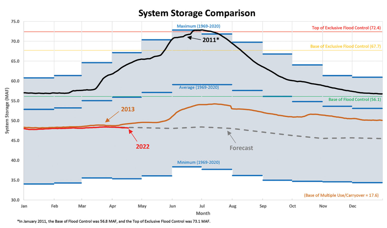
Dry conditions in April resulted in well-below-average runoff in the upper Missouri River basin. April runoff was 1.5 million acre-feet (maf.), which is just 51 percent of average. The updated 2022 upper basin runoff forecast is 17.8 million acre-feet, 69 percent of average, which, if realized, would rank as the 23rd lowest calendar year runoff volume.
“Despite recent snow and rainfall events, 84 percent of the upper basin continues to experience abnormally dry conditions,” said John Remus, chief of Corps of Engineers’ Missouri River Basin Water Management Division. “Current drought conditions, dry soils and below-normal mountain snowpack resulted in the below-average 2022 calendar year runoff forecast.”
The NOAA Climate Prediction Center indicates increased chances for cooler and wetter-than-normal conditions for most of the basin for the month of May, potentially providing much-needed moisture to the area. However, long-range forecasts for the months of June, July and August indicate warmer and drier-than-normal conditions.
System storage is currently 48.3 maf., 7.8 maf. below the base of the Annual Flood Control and Multiple Use Zone. System storage is expected to remain in the Carryover Multiple Use Zone during 2022.
Mountain Snowpack
The mountain snowpack appeared to have peaked in late April, but recent storms and cooler temperatures have resulted in additional snowpack accumulation, the Corps said. Snow over the weekend increased the snow water equivalent in both reaches, with the May 1 snowpack in the reach above Fort Peck and in the Fort Peck to Garrison reach at 86 percent and 94 percent of their normal peaks, respectively. The late season mountain snowpack has slightly increased runoff projections for May, June and July in the Fort Peck and Garrison reaches.
Navigation
Gavins Point Dam releases will provide minimum-service navigation flow support at all four target locations (Sioux City, Omaha, Nebraska City and Kansas City) through July 1. Flow targets may be missed to conserve water if there is no commercial navigation in a given reach, the Corps said. Minimum-service flow targets range from 25,000 cfs. at Sioux City, Iowa, to 35,000 cfs. at Kansas City.
Flow support for the second half of the navigation season, as well as the navigation season length, will be based on the actual system storage on July 1. The current forecast indicates that minimum service flow support will be required throughout the navigation season, and flow support may be shortened by about two weeks.


