

St. Louis Engineer District Celebrates Rich History
This year, the St. Louis Engineer District celebrates its 150th anniversary. It’s a history packed with significant moments not only for St. Louis and the region, but for our nation’s story as well. The St. Louis District often took the lead as the Corps of Engineers’ responsibilities and mission were expanded by Congress.
Matt Jones, St. Louis District project manager, is supervising the district’s ongoing celebrations of its 150th anniversary through September, the close of the fiscal year. The celebration kicked off in February with an event including the mayors of Alton, Ill., Grafton, Ill., and St. Louis.
Besides continuous postings to the district’s Facebook page and other social media sites, each month will feature a different focus on one or another of the district’s various missions, Jones said. May will highlight National Dam Safety Awareness Day on May 31 and will draw attention to the district’s many recreational project sites as summer moves into full swing. June is the Army’s birthday, and the St. Louis District hopes to engage senior Army leaders in events. Recreation and navigation will be the focus of July, when boating season is at its height. August events will focus on Mark Twain Lake and National Hydropower Day. Finally, in September, which is also National Preparedness Month, events will focus on the district’s flood management mission, which always goes on behind the scenes with little recognition.
Storied History
The St. Louis District was officially established in 1872, but its roots date back to 1837, when Lt. Robert E. Lee, a trained military engineer and recent graduate of the United States Military Academy at West Point, was assigned to St. Louis by Congress to study navigation-related harbor problems.
The St. Louis District’s mission first expanded during the early 20th century when Congress recognized the integral relationship between navigation and flood control on the nation’s inland waterways. The Flood Control Act of 1936 officially added flood control to the mission statement of the Corps of Engineers.
Public Works On Lock And Dams
In the aftermath of the stock market crash of 1929, temporary shantytowns of unemployed and homeless people, dubbed “Hoovervilles,” sprang up around the nation. One of the largest was on the banks of the Mississippi River in St. Louis, just south of the Free (MacArthur) Bridge. There, some of the 50,000 St. Louisans without jobs scraped by as best they could in shelters made of old car parts and packing crates.
After his election in 1932, President Franklin Roosevelt pushed Congress to pass public works bills to put some of the unemployed to work. In late September 1933, the St. Louis District Engineer, Maj. William A. Snow, was notified that Public Works Administration funds had been allocated to the St. Louis District for river construction works. In 1935, the Emergency Relief Appropriation Act—”the greatest single appropriation in the history of the United States or any other nation” up to that time—provided funds for the PWA.
Within a month, the first work using PWA funds was begun. PWA and WPA (Works Progress Administration) funds were used for dike and revetment construction, bank clearing and lock and dam construction. (Lock No. 25 would use WPA funds. Lock and Dam No. 26 would use PWA funds.) These projects produced beneficial, long-term results—they were not just make-work, as was said of some WPA projects at the time. By April 1936, the district had spent $12.3 million in emergency funds, resulting in 6 million man-hours of employment.
In 1928, the district’s northern boundary had been extended from the mouth of the Missouri River to the mouth of the Illinois River. Five years later, the boundary was pushed farther, to Clarksville, Mo., making the district responsible for 300 miles of the Mississippi River.
9-Foot Channel
The 1927 River and Harbor Act had authorized a survey of the Mississippi between St. Louis and Minneapolis with a view to securing a 9-foot channel. The River and Harbor Act of 1930 authorized the 9-foot channel project.
To achieve the 9-foot depth, a series of 29 locks and dams would have to be built in the Upper Mississippi River. The St. Louis District was responsible for the design and construction of the bottom three steps of the “aquatic staircase”—Lock and Dam No. 24 at Clarksville, Mo.; Lock and Dam No. 25 at Cap au Gris, Mo.; and Lock and Dam No. 26 at Alton, Ill. The Alton project was the first to be undertaken.
Work on the main and auxiliary locks began in January 1934. At all locations, the locks were constructed first so that river traffic would not be interrupted.
By 1940 the St. Louis District had completed its portion of the 9-foot canalization project, and the district engineer reported that a 9-foot channel was being maintained for the first time in that part of the Upper Mississippi.
In 1931, the Corps had estimated that the entire project would cost $140 million. By the end of the decade, the estimate had been revised upward to $170 million because of changes in the project—still a relatively modest investment, because of the availability of cheap labor during the Depression.
During its first year of operation, 1.4 million tons of cargo passed through the Alton lock. The port of St. Louis became the northernmost lock-free port on the Mississippi River.
Revitalizing Navigation And Commerce
The 9-foot channel project revitalized commercial trade on the Mississippi River. The major navigation-related responsibility of the district continued to be the regularization of the middle Mississippi River. Between July 1930 and June 1945, the district expended almost $19 million on new dikes and revetments on the middle Mississippi. Of that amount, $3.5 million came from Public Works funds and $664,000 from Emergency Relief funds, appropriated when the Corps was being ordered to create new construction jobs to fight unemployment.
The amount spent on new work in this 15-year period was as much as had been spent previously on new work in the project’s entire history. The results were impressive: 768 dikes were constructed, totaling 404,000 linear feet, and 224 revetments, totaling 276,000 linear feet. In conjunction with dredging, this construction helped maintain a 9-foot channel, which meant larger and deeper-draft barges could be used. The hazards of navigation were greatly reduced by the 9-foot depth; and the increased efficiency and reliability of barge traffic made possible by the 9-foot channel resulted in lower freight rates both by rail and by water.
Before the 9-foot channelization, barge tows had carried maximum payloads of about 5,000 tons. After it, they could carry a maximum of 50,000 tons, facilitating the rapid growth of the nation’s economy.
‘Brown-Water Navy’
Though not 100 percent completed, the 9-foot channel improvements had come just in time for Mississippi River shipyards to serve a vital role in building and transporting military vessels. During the World War II years, a total of 3,943 Army and Navy craft and other vessels for use in the war—destroyer escorts, fleet submarines, landing craft, freighters, tankers and oceangoing tugs—moved from inland shipyards down the Mississippi to the sea. Of that number, more than 2,000 passed St. Louis, including submarines in floating drydocks.
“If for no other reason, the total expenditure for regulating works was justified,” wrote Col. Rudolph E. Smyser, Jr. Such navigation would not have been possible without the Corps’ modifications of the Mississippi channel.
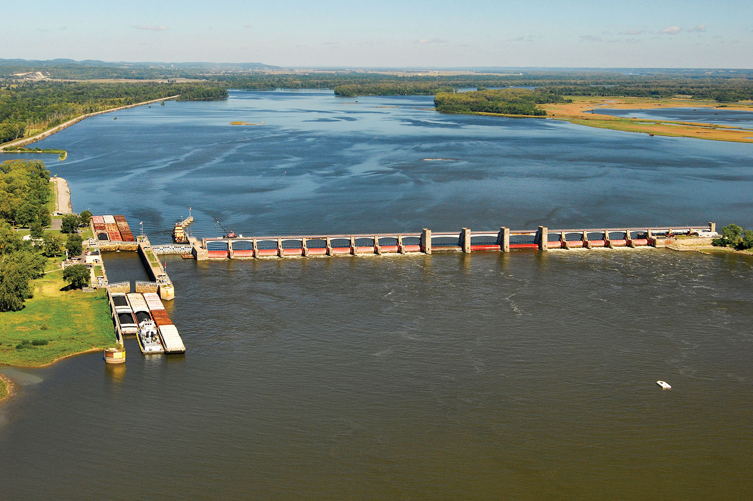
Chain Of Rocks Canal
For the full benefit of the 9-foot channel to come to the Upper Mississippi, one important obstacle remained: the Chain of Rocks, a series of dangerous rocky ledges and obstructions in the river north of St. Louis. As for the 17-mile nightmare of rock ledges, in 1947 the Corps began construction on what would become known as the Chain of Rocks Canal and Lock and Dam No. 27, the last and most southerly lock and dam on the Mississippi.
“When the Chain of Rocks Canal and Locks 27 were originally constructed, it was one of the largest [Corps] projects,” said Brooke Magary, a public affairs specialist with the Corps of Engineers. “It has since been surpassed by other projects such as the Melvin Price Lock and Dam, Olmsted Lock and Dam and the New Orleans Hurricane and Storm Damage Risk Reduction System.”
Locks 27 moves more cargo than any other navigation structure on the Mississippi River. The structure is situated near the southern end of the 8.4-mile long, man-made Chain of Rocks Canal.
During construction of the canal, an opportunity to capitalize on the potential for the region was realized. Not only is Locks 27 the last lock on the river, providing free flowing navigation all the way to New Orleans, but when the Corps constructed the canal, it dug out a 1-mile notch to be used for future barge fleeting and transloading needs. America’s Central Port in Granite City, Ill., credits its existence to the facilities built then.
Ecological Benefits
The 9-foot channel’s importance extended beyond navigation and war preparation. Ira Gabrielson, director of the Fish and Wildlife Service in the 1930s, claimed in a 1943 book that no single conservation organization helped wildlife as much as the 9-foot channel did. Previously, it was common for millions of fish to be caught in sloughs by low water and die. “In fact, the state of Illinois even built and operated a steamboat whose main purpose…was to rescue these dying fish and put them in deeper water.” Another way the project contributed to the welfare of fish and wildlife was by reclaiming 194,000 acres of sloughs and back water that the Corps gave to state and federal wildlife services for use as wildlife refuges.
Postwar Growth
World War II had shown that barges could provide a cheap, dependable means of transportation for bulk items, and shippers increasingly used the waterways in the postwar years. The combination of advances in the design and construction of towboats and barges, and improvements in navigation conditions, presaged a bright future for waterborne commerce.
The renewed viability of river traffic was shown by the federal government’s decision to get out of the barge business after 35 years, when it sold the Federal Barge Line to private investors in 1953. River transportation no longer required federal guarantees; by 1953 there were more than 700 transportation lines on the Mississippi River system and along the Gulf Intracoastal Waterway. More than a hundred of them were headquartered in St. Louis, including two of the biggest—the Mississippi Valley Barge Line Company and the Federal Barge Lines Inc.
Lock And Dam Modernization
By the 1950s, it was obvious that the Alton lock and dam had structural issues requiring significant repair. Furthermore, it was already too small for existing traffic demands. The St. Louis District began planning for replacement of the lock, but new environmental requirements delayed and altered the plans.
Although the Alton dam had used the best engineering principles of the time, unforeseen engineering issues surfaced following its completion. The structure’s foundation was not stable, as the vertical piles that anchored it were driven into sand that rested atop overlying bedrock. Because of scouring and filling during construction, foundation materials under much of the dam were much weaker than when initially tested. The weak foundation caused the structure to shift, with lock walls moving as much as 10 inches and dam piers moving more than 2 inches downstream. This produced cracking, joint separation, under-seepage and voids that developed around the piles.
Scouring below the dam caused a 300-foot-long and 10-foot-deep hole to develop. One diver investigating the structures said that the piles were so exposed that it was like walking through a forest. To ensure its stability, the Corps performed numerous costly repairs. These repairs would have to continue in the years to come just to maintain the structure, and far more costly expenditures were required for long-term solutions.
Annual tonnage through the lock had increased to 40 million tons a year by 1967. By 1974, traffic at the Alton lock totaled 52.9 million tons. Its 600-foot lock chamber was not keeping up with tows, and split tows and increasing delays made it a congested choke point.
Would rehabilitation be enough, or was a complete new lock and dam necessary? Complete replacement was first suggested in 1964, but the final recommendation wasn’t made until 1969. It was controversial; beginning in 1974, environmental groups tied up the project in litigation for years. After many funding struggles, the Melvin Price Locks and Dam was opened in 1989. In 1990, the old Lock 26 was finally demolished.
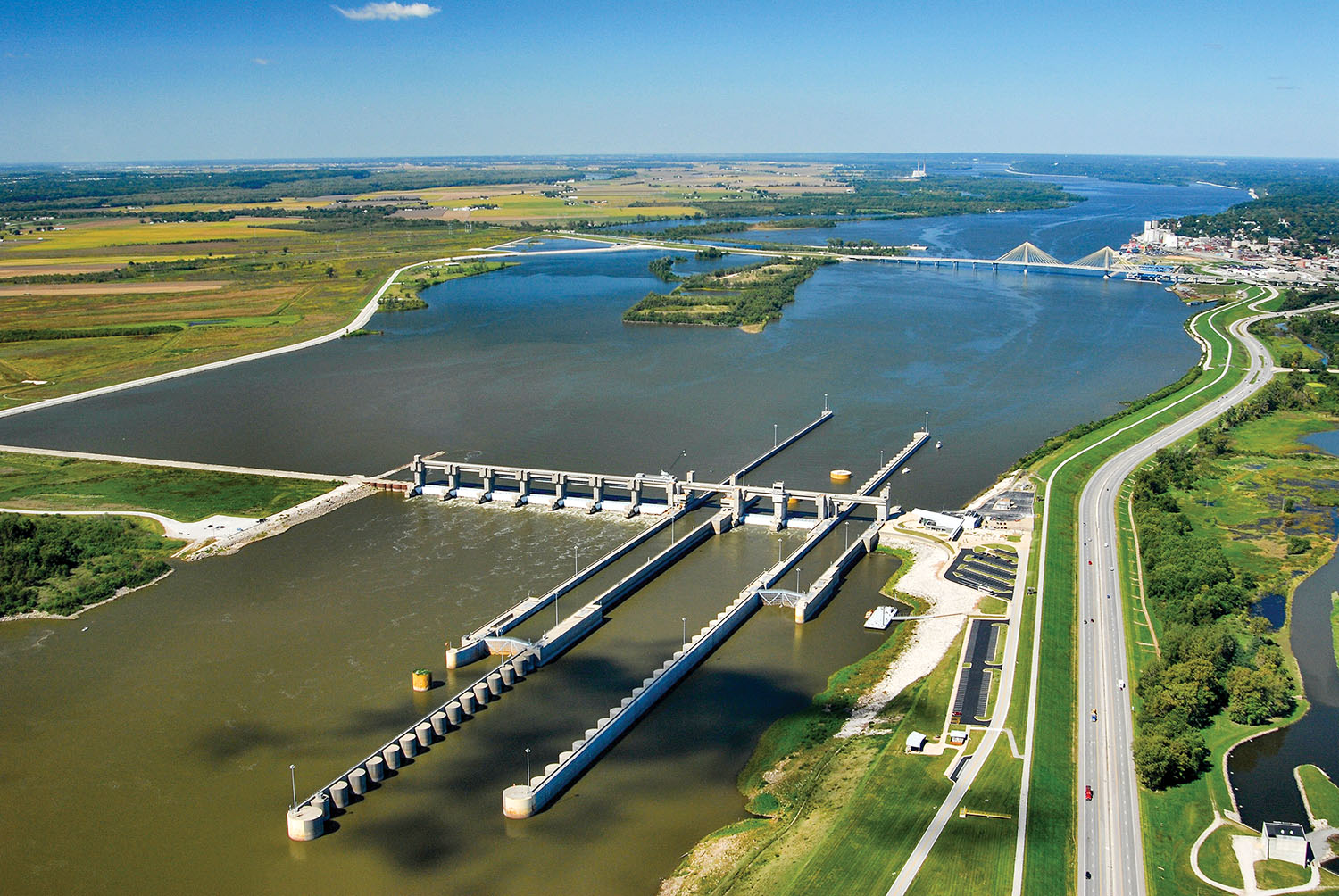
The Melvin Price Locks and Dam was the first replacement of an original installation of the 9-foot channel project. Throughout its development, the Corps used extensive computer-assisted design, testing and evaluation to create a structure that represented the state of the art in river navigation control works. Corps projections for navigation growth proved accurate, as 80 million tons moved through the 86 million-ton-capacity lock in its first year of operation.
Changes In Corps Tasks, Priorities
The period after 1960 saw further expansion in Corps activities, policies and priorities. A series of new laws added water resources management to the Corps’ portfolio of responsibilities. In 1965, the Water Resources Planning Act established the Water Resources Council and a number of river basin commissions charged with long-range comprehensive planning for a national water resource program. In 1968, Congress passed the Wild and Scenic Rivers Act. Most important of all was the National Environmental Policy Act of 1969, which “established a new philosophy to guide federal thinking and activities which may affect the nation’s natural environment.” The National Dam Safety Act of 1972 called for an inventory of all dams over a specified size. And the St. Louis District was given responsibility for inspecting dams in Missouri.
Efforts to curb water and air pollution were contained in the Environmental Quality Improvement Act of 1970 and in the Federal Water Pollution Control Act of 1972. These acts would affect standards applied by the Corps in its environmental impact statements, as well as changing the Corps’ national priorities.
The 1972 Act took away some Corps functions, including determination of “the need for, value of and impact of water storage for water quality control in any Corps reservoir,” which the Act assigned to the newly created Environmental Protection Agency. Responsibility for issuing permits for discharges into navigable waters (except for dredging and filling activities) was also transferred to the EPA. However, the Corps permit program, whose original authority came from the 1899 River and Harbor Act, was expanded by the 1972 Act.
Section 1103 of the 1986 Water Resources Development Act created the Environmental Management Program, which the St. Louis, St. Paul and Rock Island Engineer districts administer in partnership with a number of other agencies, including the U.S. Geological Survey, the Environmental Protection Agency, the Fish and Wildlife Service and five statesMissouri, Illinois, Minnesota, Iowa and Wisconsin. By 2010, the EMP had led to the enhancement and restoration of more than 95,000 acres of vital habitat.
Disaster Response, Levee Repair
The involvement of the St. Louis District in hurricane response originated in 1998 with the Readiness 2000 program. Corps headquarters developed the program to guide division-level response to major disasters using multidiscipline and multidistrict planning and response teams, pre-scripted mission assignments and advanced contracting.
Assigned the mission of supporting the Mississippi Valley Division in responding to a hurricane event, the St. Louis District first fulfilled this mission in the aftermath of Hurricane Katrina. Striking on August 29, 2005, Katrina was the most devastating hurricane in history, causing $81 billion in damages, together with Hurricane Rita, which struck less than a month later on September 24 in western Louisiana.
The St. Louis District had responsibility to oversee construction or rehabilitation of more than 220 miles of levees and floodwalls in a mere nine months, one of the largest construction projects ever attempted by the Corps.
Caption for top photo: Locks 27 near St. Louis. (Photo courtesy of St. Louis Engineer District)