Corps Activates Bonnet Carré Spillway
The New Orleans Engineer District began opening the Bonnet Carré Spillway last week to divert a portion of the flooding Lower Mississippi River into nearby Lake Pontchartrain and on to the Gulf of Mexico. The Corps activates the spillway, located about 33 miles upriver from New Orleans, when the flow of the Mississippi River at Bonnet Carré reaches 1.25 million cubic feet per second (cfs.). The structure is designed to prevent the river from getting above 17 feet—or 1.25 million cfs.—at the Carrollton Gage in New Orleans.
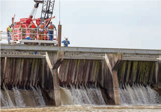
The Corps opened an initial 10 bays of the spillway March 8 and will continue opening bays as needed over the next several weeks to stay below that 1.25 million cfs. threshold.
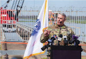
“In New Orleans, the system is designed to accommodate 1.25 million cfs.,” Col. Michael Clancy, commander of the Corps New Orleans District, said in a March 5 press conference ahead of the spillway’s opening. “After that, there are challenge areas in the system that could pose a flood risk to the city. To prevent that, we operate the Bonnet Carré Spillway.”
The Bonnet Carré Spillway, completed in 1931, is a 7,000-foot-wide weir consisting of 350 bays on the east bank of the Mississippi River in St. Charles Parish, La. Each bay is about 20 feet wide and consists of 20 creosote timbers. The Corps removes the timbers via a rail-mounted crane in order to regulate the diversion from the river to the lake. With all 350 bays opened, the Bonnet Carré, the southernmost floodway on the Mississippi River and Tributaries system, can divert a total flow of 250,000 cfs. from the river. That fresh water then flows about six miles in a northeasterly direction to the brackish waters of Lake Pontchartrain, which connects to the Gulf of Mexico through a narrow pass called “the Rigolets” and Lake Borgne.
The Corps anticipates opening about half the spillway’s bays this year, with an anticipated peak flow of 130,000 cfs.
“Right now, we’re looking at operating the spillway for about three weeks, 20 days or so,” Clancy said. “Of course, we’ll adjust that accordingly. If it drops faster, we’ll obviously shut down Bonnet Carré sooner. If we have more rain in the valley, we’ll have to operate Bonnet Carré longer.”
Looking farther upriver, Clancy said the Corps does not plan to open the Morganza Floodway, located above Baton Rouge, La. Morganza can divert up to 600,000 cfs. from the Mississippi River and eventually into the Atchafalaya River Basin. The trigger for the Morganza Floodway is when the Red River Landing Gage on the Mississippi River reaches 57 feet, with a flow of 1.5 million cfs. Forecasts place the river cresting at 60 feet on about March 20, but with a peak flow of 1.4 million cfs.
“Based on the current projections, or forecasts, we do not anticipate activating the Morganza Floodway,” Clancy said. “Of course, that is subject to change based on Mother Nature and how much rain we get in the Mississippi Valley.”
Maj. Gen. Richard Kaiser, commander of the Corps’ Mississippi Valley Division and president of the Mississippi River Commission, joined Clancy at the Bonnet Carré Spillway the morning of March 8 to announce the spillway’s activation and oversee the opening of the first bay.
“The purpose of the Bonnet Carré Spillway is to relieve pressure on local levees, to lower the river stage and reduce the velocity of the river current as it moves toward New Orleans,” Kaiser said, later adding, “This spillway is an essential component of the Mississippi Rivers and Tributaries Project (MR&T), which stretches far north of hear, upwards to Cairo.”
Overviewing the project for onlookers gathered for the spillway opening, Kaiser said that, for every dollar spent on the levees, locks and floodways in the system, the nation has received $67 in economic benefits and damages prevented.
“In 2011, which was a flood of historic proportions, the MR&T Project saved over $234 billion in damages, and not a single life was lost in Louisiana,” Kaiser said. ”And this spillway was part of those savings.
“These structures and this system is a great example of how flood control, navigation and the environment can work together,” he added.
Besides the deep water anchorage at Bonnet Carré being off limits, Clancy said operation of the Bonnet Carré Spillway should have little impact on navigation. The Corps and Coast Guard restrict vessels using the anchorage near the spillway due to the lateral flows of the river toward the weir.
This is the 12th time the Bonnet Carré Spillway has been opened in the structure’s 87-year history, although a third of those times have come in the past 10 years. Prior to this year, the Bonnet Carré has been opened in 1937, 1945, 1950, 1973, 1975, 1979, 1983, 1997, 2008, 2011 and 2016. The earliest opening of the Bonnet Carré Spillway came two years ago, when the Corps began opening bays on January 10, 2016.
In addition to activation of the spillway, the Corps also last week initiated its phase 2 flood fight, which involves daily monitoring of levees on both sides of the Mississippi River. Construction within 1,500 feet of the crown of the levee also must halt, and tows are prohibited from pushing in or tying off within 180 feet of the crown of the levee.
There is a chance Old River Lock could close to navigation during this high-water period. The trigger for closing Old River Lock is 60.5 feet at the Red River Landing. Current projections call for the Red River Landing Gage to briefly reach 60 feet around March 20 before the river starts to fall.