Wax Lake Outlet Presents Particular Challenges
Spring has arrived—that special time of year when an Intracoastal pilot’s thoughts turn to the challenge of crossing the Wax Lake Outlet.
When the rivers are high, the Morgan City-Atchafalaya Basin area is a veritable obstacle course for mariners. If you come down the Atchafalaya or the Port Allen Route, you have to skillfully set yourself up to get sucked safely through the Morgan City bridges. If you go west on the Intracoastal, you have to carefully poke the hole at “the 99,” near Mile 99 WHL.
But whether eastbound or westbound, you have to cross “the Wax,” as it’s known on the boats.
The Wax Lake spillway is a man-made diversion that siphons flood water away from the Atchafalaya River and shoots it straight out to Atchafalaya Bay and the Gulf of Mexico. It crosses the Gulf Intracoastal Waterway at right angles near Mile 108 WHL. In a serious flood year, the discharge can amount to a quarter million cubic feet of water per second (cfs.). Each one of those cubic feet wants you to go south, instead of east or west.
More than a hundred miles upstream, the Atchafalaya takes about 30 percent of the Mississippi’s flow via the Old River Control Structure. Then the Wax Lake diversion takes 30 percent of the Atchafalaya’s, detouring it around Morgan City and reducing pressure on the levees there. That’s why we end up with extreme currents on the Intracoastal at Morgan City, and then another dollop of crossways current at Mile 108.
The smaller Charenton Drainage and Navigation Canal, which crosses the Intracoastal at Mile 123 WHL, just west of the Mud Lake wiggles, also gets its water from the Atchafalaya River. But the Charenton is not directly connected to the Wax. It has its own intake structure farther upstream. The discharge through Charenton maxes out at about 20,000 cfs., while the Wax was designed with a capacity of 300,000 cfs.
The Wax Lake Outlet was actually constructed more than 20 years before the Old River Control Structure came online. The Old River low-sill and overbank-control structures were completed in the mid-1960s. Wax Lake was up and running in the early 1940s. The need for flood protection was so critical that the Corps was busy in the Atchafalaya Basin even while the military was needed on the front lines in World War II.
Bridges, Then Water
As part of the Atchafalaya Basin project, the new Charenton and Wax Lake canals were going to need bridges over them, to carry Highway 90 as well as the (then) Southern Pacific Railroad. The engineers had an interesting way of building them. In a curious take on the adage about “water under the bridge,” they built the bridges on dry land, then put the water under them. Counting the long elevated roadways across the flood basin, the engineers built a total of six bridges this way.
The sight of a railroad swing bridge in a cane field at Baldwin must have been as odd as that of a steamboat in a cornfield, but it was easier and less expensive to go with land-based construction, bringing in material and equipment by truck instead of by barge, and then to dig channels under the bridges.
The same also goes for the Bayou Teche floodgates at Calumet. The bayou crossed the intended route of the Wax at right angles just like the Intracoastal did. Excavation and construction of the floodgates was carried out on dry land a few hundred yards north of the natural course of the bayou. Once the gates were completed, short cutoff canals were dug to them, the original stretch of bayou was dammed off, and then the Wax Lake Outlet canal could be dug.
The last “plugs” of land were dredged out at Calumet and Baldwin in 1941 and 1942, and the current started flowing. The outlet is more than 15 miles long, starting at Six Mile Lake, an offshoot of the Atchafalaya River, then down a straight canal, across Bayou Teche and the Intracoastal, through a small body of water called Wax Lake, then off toward the Gulf. The channel was dug to a depth of 45 feet below mean Gulf level, with a bottom width of 300 feet from Six Mile Lake to just below the Calumet bridges, then widening out to a bottom width of 400 feet the rest of the way south.
Navigation Crossover
Planners knew from the get-go that “crossing the Wax” would be a tricky maneuver during high water. In May 1942, district engineer Col. DeWill C. Jones warned that the current at the Intracoastal intersection “may reach such velocity that difficulty will be encountered by tows attempting to negotiate the straight crossing.” This is not news to towboat mariners on the west run today.
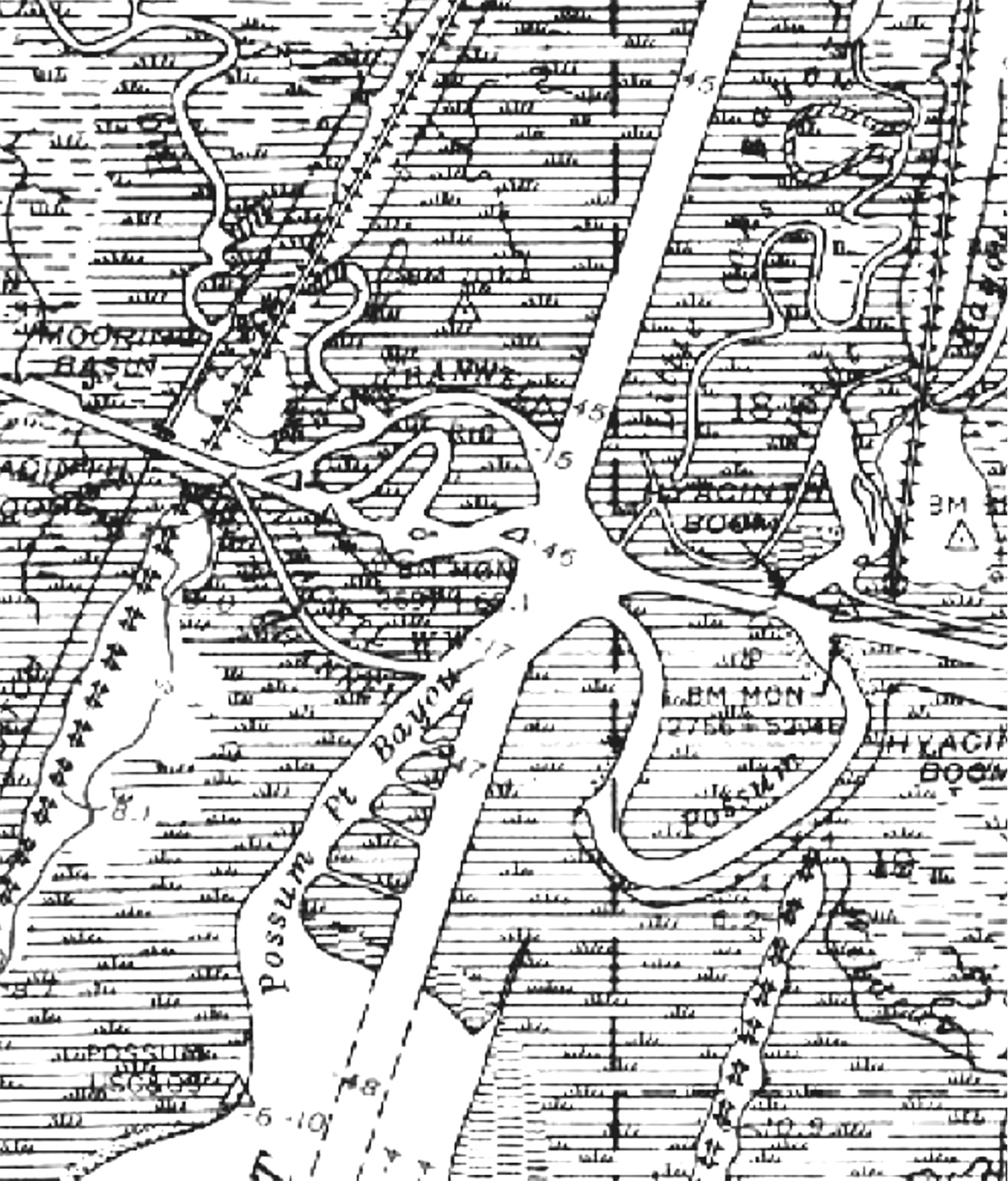
The engineers attempted a fix for this. Two short, curved channels were dug on the west side of the spillway, one to the north and the other to the south of the Intracoastal. As Col. Jones explained, “two channels have been provided known as Wax Lake Navigation Crossover. Westbound traffic will use the north channel and eastbound traffic the south channel.” The idea was that a westbound tow would pop out of the hole and immediately steer hard to the north and be able to enter the north loop at an angle. An eastbound tow would use the south loop to set up and enter the Wax at an angle.
That didn’t last long. By the 1980s, at least, the two little side-channels had silted up. Vestiges of them can be seen in vegetation patterns in satellite view at 29.648 degrees north, 91.393 degrees west. Some digital maps and charts still show the names “Wax North Channel” and “Wax South Channel” when zoomed in, but there’s usually not enough water there to float a pirogue.
The Army Engineers were forward-thinking and navigation-savvy enough to provide “mooring slips and pile clusters … on each side of the crossing for making up and breaking up tows whenever necessary,” so that a long tow could be taken across one or two barges at a time. At times over the decades there have been heavy-duty mooring buoys deployed there for the same purpose.
Land Formation
A pleasantly surprising effect of the outlet has been its contribution to land formation in Atchafalaya Bay. While the Louisiana coast as a whole has been losing ground, the Atchafalaya River and Wax Lake Outlet have been creating new real estate. The Mississippi Delta has lost 2,000 square miles in the last 80 years, but land in and around Atchafalaya Bay has been growing by an average of one square mile per year since the major Mississippi River flood of 1973.
One reason for this is that the Wax created a second delta in the bay. Another reason is that, although the Wax is an artificial outlet, its delta has been allowed to grow undisturbed, without channel dredging or other human interference that would cause sediment to be lost to the deep waters of the Gulf.
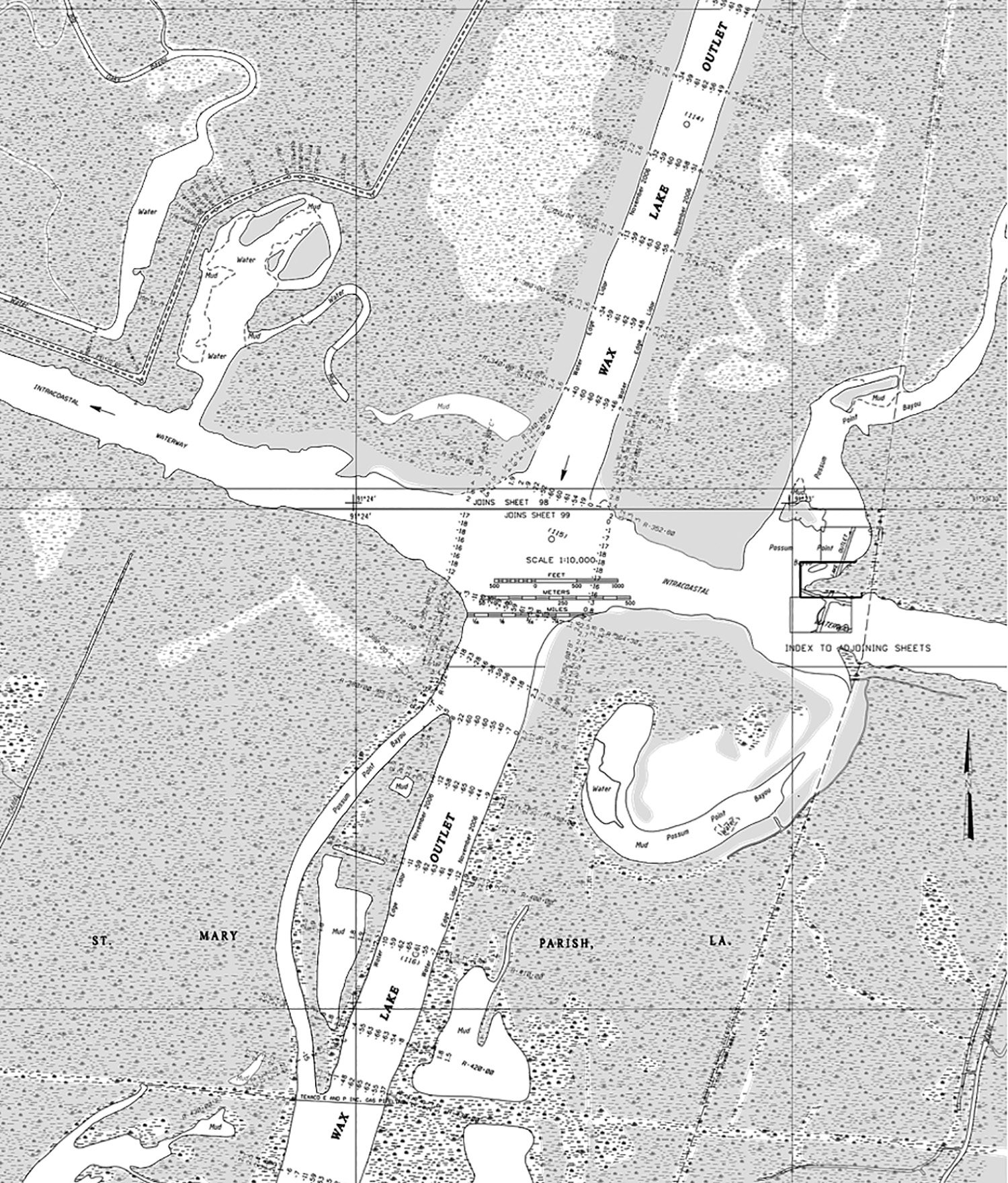
But along the way, the Wax also deposits some sediment right there at the Intracoastal crossing. The intersection needs to be dredged just about every year, depending on how much of a flood there’s been. The last time it was dredged was in 2016.
In addition to the straight 12- by 125-foot channel, the Corps dredges wide into the four corners of the intersection so that an east- or westbound tow can be steered high into the spillway current, then have some wiggle room getting back into the Intracoastal on the other side.
The modern-day Intracoastal mariner has numerous digital tools available to enhance safe navigation. One of them, especially useful at a place like the Wax Lake Outlet crossover, is realtime water data from the U.S. Geological Survey (USGS). A mariner, or anyone with a cell phone, can text “07381590” to waternow@usgs.gov and receive, in a few seconds, the discharge rate and the gage height at the Wax. The gage is located just south of the Highway 90 bridge at Calumet, 3.5 miles north of the Intracoastal.
Sending a blank email to waternow@usgs.gov, with “07381590” in the subject line, yields more complete data. The Calumet site also reports speed of current, but that parameter only came online in October 2017, so it doesn’t have much background data for comparison, and it hasn’t been through a spring flood.
What’s more, a mariner can review historical data to get an idea of what kind of numbers are generated during a serious flood event, and use that insight to help inform navigation decisions in advance. The USGS website can be a bit cumbersome to navigate, but an online search for “Wax Lake outlet data” should lead to the USGS Calumet site and other data reporting sites, including the Charenton.