Corps To Study Extending Navigation On Red River
The Vicksburg Engineer District announced on June 5 that it will prepare an environmental impact statement (EIS) to evaluate whether shallow-draft navigation should be extended on the Red River from Shreveport, La., northward into Arkansas, possibly up to 135 miles.
The Arkansas Department of Agriculture Natural Resources Division will perform the EIS. The Corps of Engineers’ Federal Register announcement is the formal step that starts the EIS process. An extended channel on the Red River, formally called SWARRN, Southwest Arkansas Red River Navigation, has been an active topic for many years. A possible extension was previously evaluated by the Corps in a 2005 draft feasibility report. For this new initiative, the Corps held public “scoping meetings” last July in Shreveport and Texarkana, Texas.
The Red River starts in the Texas panhandle and flows east approximately 1,290 miles, forming the border between Oklahoma and Texas as well as part of the border between Texas and Arkansas. About 180 miles of the Red River is within Arkansas.
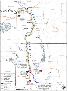
The existing Red River navigation channel, known as the J. Bennett Johnston Waterway, extends from the confluence of the Old, Red and Mississippi rivers near Simmesport, La., to near Shreveport, a distance of about 236 river miles. The waterway has five navigation locks.
The EIS will focus on three possible alternatives, all of which start at Shreveport. One will evaluate extending a navigation channel to Garland, Ark., or about 74 miles to the north. The second consider extending navigation up to to Fulton, Ark., about 100 miles north. The third possible terminus is at Index, Ark., just north of Texarkana. Extending navigation to Index would add about 135 river miles to the waterway. Heading north, the Red River’s course goes to Garland then to Fulton, where it bends west toward Index and the state of Texas.
Over the centuries, the meandering Red River has caused floods and erosion. In June 2015, for example, Garland was evacuated because of heavy flooding. Due to floods and river erosion, none of the early historic structures of Fulton survived to the 21st century. These are small towns. Garland and Fulton, for example, each have a population of around 200.
As a free-flowing river, according to the Corps’ 2005 feasibility report, the “natural depths in the Shreveport to Index reach of the Red River are not sufficient to sustain year-round commercial navigation.” That report states that controlling depths from January to July are approximately 4 feet, and generally less than 1 foot for the remainder of the year. Commercial navigation would require at least 9 feet of dependable depth. Plus, shoaling and sharp bends present hazards.
Each possible channel alternative will require a series of locks and dams. The vertical lift to Garland is approximately 54 feet, requiring two locks and dams. To Fulton, the elevation change is 75 feet, likely requiring three locks and dams. The lift to Index is 102 feet, requiring three high-lift locks and dams. A high-lift system, according to the Corps of Engineers, is employed to manage larger elevation changes and require larger lock chambers to increase efficiency.
Each alternative, according to the Corps, will require a navigation channel geometry with a depth up to 12 feet and revetments and dikes to provide channel and bank stabilization. The Corps stated that “all feasible and reasonable alternatives will be considered for detailed analysis.” The EIS could also consider a “No-Action” alternative, meaning that none of the proposals would advance.
The Corps is moving forward with an EIS now because an updated market analysis and economic review demonstrated “the potential for improved NED benefits,” meaning the “national economic development” picture may be more favorable now compared to when the 2005 feasibility report was done.
The updated analysis is from 2018. Chris Colclasure, director of the Arkansas Department of Agriculture’s Natural Resources Division, said the update indicated new businesses, population growth and potentially increased tonnage extending from the Caddo-Bossier Port near Shreveport through southwest Arkansas. Additionally, Colclasure noted that the Corps now allows the consideration of Regional Economic Development (RED) benefits, which would increase the cost-benefit ratio of extending navigation into Arkansas.
The primary NED is transportation cost savings. This navigation feasibility study will work to identify potential users of navigation shipping who may realize reductions in transportation costs. Other economic benefits that will be evaluated will include potential water supply, recreation, flood reductions and water quality benefits.
Comments should be sent by July 7 to CEMVK-PPMD-Civil-Works@usace.army.mil. The Corps plans to have the EIS ready for public review by May 2026.